We realize that some of you may not be following the pins in the Domain and Settlement Selection channel in Discord, where brief updates have been posted recently.
Plus, lots of people have been asking about progress and wanted more than a bunch of explanations, and we can totally understand that.
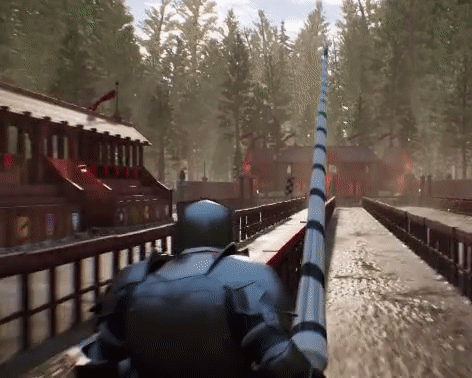
So a few moments ago, while Caspian was chatting in Discord, he shared a couple of GIFs showing our progress with Domain and Settlement Selection, and of course we wanted to share that on our forums as well.
Please remember: The data is still temporary, there's still some work to be done on both the front-end, the stylized rendering, the simulations, and our distribution of settlements.
This is to reassure people that most of the really hard technical problems have been solved now and we're getting very close. To that end, here's the D&SS site in action.
---- WORK IN PROGRESS ---- WORK IN PROGRESS ---- WORK IN PROGRESS ------
And here is an example of how selecting multiple properties may look like:
Added 6/17/2019
Earlier today, a couple of you asked what it would look like if a player were to select more than 2 counties.
Below, you will see an example of what it may look like picking multiple counties (in this demo, 6).
Please remember this is still a work in progress and everything else said in this post applies.
---- WORK IN PROGRESS ---- WORK IN PROGRESS ---- WORK IN PROGRESS ------
Again, remember that this isn't quite done yet, so be mindful that some stuff is still missing, not finalized, a WIP or placeholder. This is mostly to give people reassurance that we're almost done, and DSS is fully functional.
It won't be much longer now!!!
Stay excited, and have a wonderful rest of your week/weekend!
Until next time,
More to come...
"Stupid questions make more sense than stupid mistakes."
So in the video, it lists km^2 for estimated size of duchies, then it still says km^2 for the estimated size of counties, but with much larger numbers. Should it be saying parcels on the county screen?
Posted By Gromschlog at 02:12 AM - Tue Jun 18 2019
Posted By 1mmaculateDeception at 6/17/2019 9:53:10 PM
That was very informative. There was one point in the county picking process on that latest vid where one of the options presented was actually surprising. There appears to be more leeway with the choices than I previously thought there would be.
which choice was surprising? Didnt all choices simply count borders? thats what they told us, when we asked what their "clustering" actually means. Its all about how many touching domains you have, no matter if the shared border is tiny or huge.
Yes that is all correct. For whatever reason, I seemed to have in mind that the length of touching border would be taken into account as well but clearly that is not the case.
So in the video, it lists km^2 for estimated size of duchies, then it still says km^2 for the estimated size of counties, but with much larger numbers. Should it be saying parcels on the county screen?
Yes.
"Stupid questions make more sense than stupid mistakes."
In the video where you choose 6 counties, I am noticing that as you select more counties, rather than having more options, you sometimes lose options for your next choice. What are the rules for selecting multiple counties. I know that the borders have to be contiguous (ie no broken counties), but are there additional constraints? The video seems to imply additional constraints. An example of this is, in the video, when you claim the 2nd county, the options become reduces on what you can select for the 3rd. The 2 counties to the left of your first pick are no longer available, and the 2 counties to the right of the new county you picked also remain unavailable despite sharing a border.
All counties after the first must touch an already selected county(ies) you have claimed.
After the second county further counties must touch as many borders of the selected counties as possible (the reason of the loss of the options) in the tightest grouping as possible.
If you are unable to select a county that border 2 or more counties then you must select the longest touching border that touches one of your selected counties.
I'm just seeing this, but neat. You guys really need to create something to enlarge images or open in a new tab so we don't have to copy image location and manually open in a new tab though.


 Du suchst noch ein Zuhause in Elyria? Besuche den